


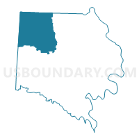
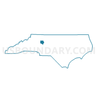
Voting District 03, Davie County, North Carolina
About
Outline

Summary
| Unique Area Identifier | 639896 |
| Name | Voting District 03 |
| County | Davie County |
| State | North Carolina |
| Area (square miles) | 39.21 |
| Land Area (square miles) | 39.01 |
| Water Area (square miles) | 0.20 |
| % of Land Area | 99.49 |
| % of Water Area | 0.51 |
| Latitude of the Internal Point | 36.00492420 |
| Longtitude of the Internal Point | -80.63006790 |
Maps

Graphs
Select a template below for downloading or customizing gragh for Voting District 03, Davie County, North Carolina


Neighbors
Neighoring Voting District (by Name) Neighboring Voting District on the Map
- Voting District 01, Davie County, NC
- Voting District 05, Davie County, NC
- Voting District 14, Davie County, NC
- Voting District DCRK, Yadkin County, NC
- Voting District EM, Iredell County, NC
- Voting District SLIB, Yadkin County, NC
Top 10 Neighboring County Subdivision (by Population) Neighboring County Subdivision on the Map
- Farmington township, Davie County, NC (11,313)
- Mocksville township, Davie County, NC (9,837)
- Clarksville township, Davie County, NC (3,766)
- Deep Creek township, Yadkin County, NC (3,326)
- South Liberty township, Yadkin County, NC (3,132)
- Calahaln township, Davie County, NC (2,673)
- Eagle Mills township, Iredell County, NC (1,912)
Top 10 Neighboring Unified School District (by Population) Neighboring Unified School District on the Map
- Iredell-Statesville Schools, NC (131,920)
- Davie County Schools, NC (41,240)
- Yadkin County Schools, NC (38,406)
Top 10 Neighboring State Legislative District Lower Chamber (by Population) Neighboring State Legislative District Lower Chamber on the Map
Top 10 Neighboring State Legislative District Upper Chamber (by Population) Neighboring State Legislative District Upper Chamber on the Map
- State Senate District 42, NC (184,148)
- State Senate District 34, NC (179,668)
- State Senate District 30, NC (170,635)
Top 10 Neighboring 111th Congressional District (by Population) Neighboring 111th Congressional District on the Map
Top 10 Neighboring Census Tract (by Population) Neighboring Census Tract on the Map
- Census Tract 801, Davie County, NC (7,745)
- Census Tract 504, Yadkin County, NC (6,729)
- Census Tract 802, Davie County, NC (5,207)
- Census Tract 505.02, Yadkin County, NC (4,389)
- Census Tract 806, Davie County, NC (3,659)
- Census Tract 608.02, Iredell County, NC (3,564)
- Census Tract 608.01, Iredell County, NC (3,482)